
90 | Child's Plaint
1997 | Wheeler Peak, Nevada
I rarely keep notes. I just found these old scribbles among miscellany, and post them here verbatim.
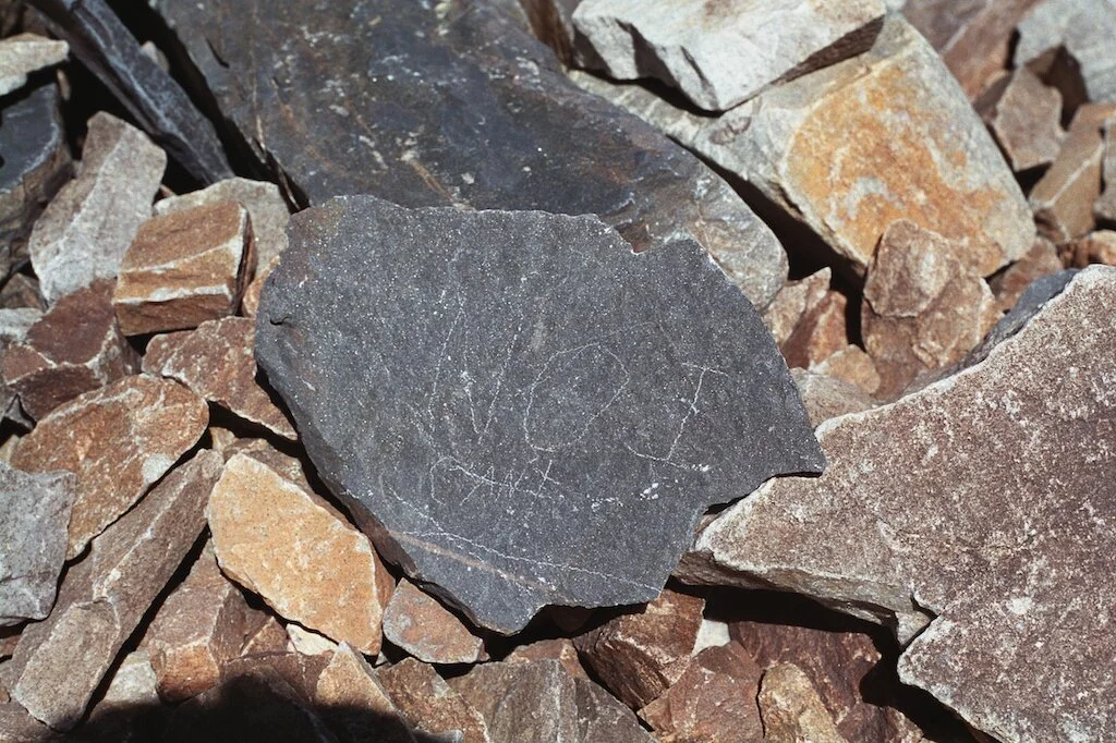
The picture here was made near the summit on our second ascent, on a sunny day the following summer.
7-15-96
Great Basin N. P.
A bit of rain in the morning.
Alex and I climbed up the to the bristlecones while Dad walked the lake loop. Still marveling at the trees; even after dying 300 years ago, their wood is strong and clear and resinous – what a way to build a boat! Most specimens very healthy. It was not easy to tell how old the young 3-foot trees were.
On up to the glacier. Alex waited at the moraine making snowballs while I climbed ahead to the wall, then a glissade down in a shower of his cold projectiles.
Huge thunderstorms all night. First, just strobes on the horizon, silent. Then distant thunder with increasing light and then boom, flash, hail; rain most of the early morning.
Big breakfast, strike camp, and detach huge mouse-nest from underneath the carburetor. Then on the summit trail before 8am, trusting the clouds would clear. Dad sent us off at the hikers’ register, finally superannuated by his 75 years, still walking well at 10,000 feet, but no longer seeking higher adventure.
Very cold and windy on the first exposed leg, then extremely cold and windy (40-50) for the final 1.5 miles straight up the ridge with no suggestion of switchbacks. The tundra wildflowers and birds accompanied us all the way to the top. Above 12,000 not even the teaser breaks in the cloud gave us glimpses of the basin and alpine lakes straight below. About the time our legs gave out, the gradient faded a bit, and Alex spotted the summit rock shelter. We explored the cairns to the south, added our own stone, and made a ceremonial photo into the fog.
Heading down, we were greeted with even fiercer winds and made frequent use of the rock shelters, good practice for the day we might get caught in a T-storm. Coming down, barely able to stay up in the wind, but an occasional break in the cloud gave us vertigo – the trail was so steep, the desert basin floor was askew, and the northern shoulder was striking in from above. Then, nothing.
The air seemed very thick as we passed down thru 11,000 feet.
89 | Bumpass Hell

1997 | Bumpass Hell, Mt. Lassen National Park, California
Place names are fraught. In our history, whoever names a place lays claim to it.
All over this continent, and surely across the world, appropriate names for places were coined by their inhabitants. The displacement of Native names has been very recent and bloody in the American West, though the present labels might be a prospector’s poetry. But where I can find notes, I do care for the clarity in the vision and language of the original culture which lives on in the antecedent name for a place.
This name caught my eye on a map, so my son and I walked in for a look after we climbed Amblu Kai (Lassen’s Peak). This place may have a heavenly look, but its present name sounds a warning to those who visit the boiling pools, mudpots, and fumaroles.
My camera is a tool I use to admire the present; the sites of old conflicts and misadventures can be wonderlands to enjoy on a walk in the park.
88 | Brush Creek

1997 | Near the Mouth of Brush Creek, Curry County, Oregon
I am deeply touched when I get to see how the natural world makes its own maps for us.
That’s that!
87 | Panamint Sink

1995 | Panamint Basin
There is no such thing as nothing.
If it can be named, it is there.
On a map, this basin looks empty. Some people might think that nothing is there, that nothing is going on.
But here is substantial evidence that what they call ‘empty’ is full of light.
What might be my best silver print was made from this negative. For those of you who missed the grand darkroom era of photography, the high and low ends of the tonal scale were always the most difficult to judge when printing – inspecting a wet print, we could marvel at the rich variations of dark and darker grays, and appreciate separations in the barest deposits of silver representing the lightest values. But as our prints dried, and the gelatin emulsion suspending the sparkling silver shrank, the sonorous dark values closed up and the celestial highlights would settle down into everydayness.
For this print, I exposed less and less for each trial, pushing for a lighter and lighter result, getting ahead of the ‘dry-down.’ I was still disappointed with the heaviness of the critical brilliance. On another day, I boldly started with half of the previous exposure (an enormously crude adjustment) and worked toward even less. Then, drying slowly on a mesh screen in quiet air, the print came home.
86 | Devils Cornfield

1994 | CA-190 through Devils Cornfield
As California 190 crosses Death Valley, it drops out of the Panamints toward the Mesquite Flat dunes, eases around alluvial fans, then sets straight northeast for Daylight Pass through the Funeral Mountains.
The highway here appears straight, but the chicane which alerts the driver dodges between two small volcanic heaps which can offer a little elevation to try for a bigger picture.
This looks a lot like my home planet. Don’t let the straight line fool you – it’s a very complicated place. But all I need to do is get off the highway, climb a small butte, set up on the big gravel, and the Valley does the rest.
85 | Old Spanish Trail Highway

1996 | Toward Pahrump, Nevada
When I see an interesting line on a map, I like to go there to exchange the aerial schematic view for the ground truth.
Southeast of Death Valley, ahead of me, this road goes straight east-northeast for two miles, then turns north-northeast for a straight five, and then due east for seven more straight miles before crossing an imaginary line into Nevada; there it gets a new name, turns northeast, straight again for seven more, then ‘tees’ into Nevada 160, a divided four-lane highway.
84 | American Butte

1989 | Near Caineville, Utah
Just a few miles beyond the eastern boundary of Capitol Reef National Park (one of the newest in the grand landscape of Utah, just six miles wide, but sixty miles north to south), there are good chances to stop and enjoy the geological gestures in the quiet of the high plateau, even in the unprotected places.
I am still taken in by the admirable land in this picture, which details enjoyment of an entirely different order by previous visitors, whose marks were hacked with smoke and noise.
Photographs like this give me a way to embrace persistent value after recent tragedy – to find what remains, what we still have.
83 | Roadside

1977 | East into Arizona
I can’t remember exactly where this picture was made. It feels like western Arizona, eastbound, just after clearing the bridge across the Colorado River, at the fringe of Yuma where you can gas up as you abandon the interstate for the farm road that turns into AZ-95, which bears northeast and then breaks due north into the serious rough dryness.
But it could have been taken anywhere out there, which I think is the appeal of it. Here, I am looking at a very specific place, and also a quintessential roadside experience of the entire spare and unforgettable desert Southwest.
It’s time for me to re-read William Least Heat Moon’s Blue Highways, an account of his long trip on two-lane roads in search of persistent rural America. I encountered it back in 1982 when it was published, and I can’t specifically remember a single phrase or sentence, but I carry in me a feeling of the whole experience of his book and his journey.
82 | Summer

1971 | Near Okreek, South Dakota
The Sandhills of western Nebraska, long waves rolling on old sand dunes, grassy surfaces rippling in the steady prairie wind, offer a chance to walk on an ocean.
Not far from where this picture was made, just across the South Dakota line, Harold Moore introduced me to his favorite spot near Nenzel, to the southwest. We drove across a scarce track to the base of an abandoned fire lookout tower, made the climb, and looked out at what seemed like fifty-mile horizons in every direction. Nearer, we counted Harold’s truck and an old, resting windmill. Our inventory was only those two items – we were seeing next to nothing, and it seemed like everything.
*Harold was not just a retired typewriter mechanic volunteering as a pressman at the St. Francis School, he was a deeply curious explorer. One of his shorter expeditions in 1971 was into the attic of the Mission, where he discovered glass-plate negatives from the turn of the nineteenth century and large rollfilm negatives from the 1920’s and 1930’s. Harold had attributed the glass plates to John Andersen and the rollfilm work to Eugene Buechel, a Jesuit priest and teacher who served at St. Francis for many years.
We divided the tasks to bring these to light; when I first saw the Buechel negatives, I thought right away, “These belong in the Museum of Modern Art!” John Szarkowski thought so too, after five of my California students joined me in South Dakota to work up the 2200 negatives into a proposal to the Museum, along with an exhibition catalog. Forty-one of Buechel’s pictures were exhibited at MoMA in the fall of 1975, and the portfolio was acquired for its collection.